Explore Grant County 2024: Motorcycle Riding
Published 7:00 am Wednesday, April 17, 2024
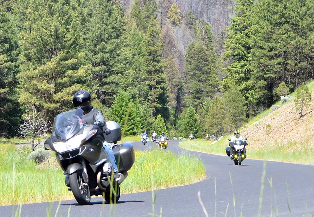
- BMW riders weave their way through curves on County Road 65. The turnoff from Highway 395, south of Canyon City, is also called Canyon Creek Lane.
Whether you prefer long and adventurous rides or short jaunts out to admire the scenery, Grant County has a lot to offer motorcycle enthusiasts. Minimal traffic, the chance to meet other cyclists, numerous restaurants in multiple cities and curvy highways are all things riders will enjoy.
Trending
Ride 1 125 miles
From John Day, head east on Highway 26 through Mt. Vernon and Dayville. About 7 miles beyond Dayville at Picture Gorge, turn north on Highway 19 and ride past the Thomas Condon Paleontology Center. Tun right at the Kimberly store to go through Monument and into Long Creek. In Long Creek, turn right on Highway 395 and continue south to Mt. Vernon. Turn left on Highway 26 and continue east back into John Day.
Ride 2 197 miles
Trending
Leave John Day and head east on Highway 26 through Prairie City. Turn left at Austin Junction and continue on Highway 7 for about 25 miles. After you’ve crossed the railroad tracks, look for the sign for the town of Sumpter. Turn left and head 2-3 miles into Sumpter. From Sumpter, continue north on the same road for another 19 miles into Granite. Continue west on Highway 244 until you reach Highway 395. Turn left and take Highway 395 south to Mt. Vernon and Highway 26. Turn left on Highway 26 and continue 8 miles into John Day.
Ride 3 11 miles
This short and easy trip provides riders with breathtaking views of Canyon Mountain and the John Day Valley. Leave John Day headed east on Highway 26 for 3 miles and take a right onto Dog Creek Road. The paved road takes a 90-degree turn onto Marysville Road (County Road 52) after a little over a mile. Riders will then descend into Canyon City and turn right, heading north on Highway 395 back into John Day.
Ride 4 108 miles
Leave John Day and head west on Highway 26 into Mt. Vernon. Turn right at the intersection and head north to Long Creek along Highway 395. A few miles north of town, turn right on County Road 20 and ride about 34 miles along the Middle Fork of the John Day River to Highway 7. Turn right onto Highway 7 and head 1.5 miles to the intersection with Highway 26 at Austin Junction. Turn right on Highway 26 and head over Dixie Summit and into Prairie City. Continue traveling on Highway 26 for 13 miles back into John Day.
Ride 5 84 miles
Depart John Day and head east on Highway 26 into Prairie City. Turn right on Main Street and continue to the junction with Bridge Street. Turn left onto Bridge Street and continue past the cemetery, where the street becomes County Road 62. Travel along County Road 62 for about 19 miles to the junction with Forest Road 16. Turn right onto Forest Road 16 and continue east for about 36 miles until you reach Seneca. Turn right onto Highway 395 and travel north 26 miles back into John Day.
Depending on the time of year, watch out for gravel on the road.
Be aware of your surroundings and be on the lookout for wildlife.
Have a plan for your trip and make sure you are adequately equipped for the ride.
Some of these rides take riders into remote areas in the mountains where cell service can be questionable.
Marketplace


-
eEdition

-

-
